Link to home
   

Special places archive

August 2003

Maps of Scotland 1560-1928

Link

The National Library of Scotland’s map collection is one of the ten largest in the world.

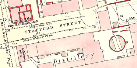
Detail from an 1860 Ordinance Survey map of Oban

Highlights include the earliest surviving detailed maps of Scotland (made by Timothy Pont in the 1580s and 1590s) and over 1,900 sheets of large scale Ordinance Survey maps of Scottish towns drawn between 1847 and 1895.

The maps have been scanned at high resolution to capture their exquisite detail. You can zoom in and out, and pan around the image. If you have a fast connection and a large screen I recommend downloading the ExpressView plug-in.


Search marquis-kyle.com.au

Subject archive
Afghanistan  2
Antarctica  1
Australia  21
Austria  1
Bangladesh  2
Barbados  1
Brazil  2
Burma  1
Canada  1
Chile  1
China  2
Cuba  2
Egypt  1
England  10
France  2
Georgia  1
Germany  3
Greece  1
Guyana  1
Haiti  1
Hong Kong  1
India  4
Iran  1
Iraq  2
Ireland  2
Israel  1
Italy  3
Jamaica  1
Kenya  1
Lebanon  1
Mexico  2
New Zealand  4
Pakistan  2
Palestine  1
Poland  1
Russia  7
Scotland  6
Spain  1
Syria  1
The Netherlands  1
Turkey  2
USA  29
Vietnam  1
Wales  2
World  5
Archaeology  4
Architecture  21
Domestic life  9
Entertainment  1
Exploration  1
Food  3
Industry  10
Landscapes  19
Lighthouses  4
Literature  3
Photography  27
Timber buildings  3
Urban infrastructure  17
Urban life  25
War  10

RSS

©
Contact me